Santiago Incident Wildfire, October 2007
This page is an archive of information about the Santiago Incident Fire near Irvine, Tustin, Lake Forest, El Toro and Rancho Santa Margarita in October 2007. At the time, there were a number of fires burning across Southern California and getting specific information about this fire proved difficult. Many people filled the information vacuum by posting individual accounts and details which surpassed anything found in the newspapers, tv or radio.
A special thanks to all the firefighters whose tireless work saved countless homes and communities. For those whose homes could not be saved, I offer my deepest sympathy.
Information
Orange County Public Information Hotline – (714) 628-7085
As of November 8th, the Santiago Fire was 100% contained but continued to burn in the Cleveland National Forest.
OC Fire Authority: Santiago Incident Report updated periodically (last update 7:20 AM 10/27/07)
- cause: Arson (OCFA Arson Tip Line: (800) 540-8282)
- approximately 28,400 acres burned
- at one point nearly 2000 firefighters were fighting on this fire.
- Several hundred OC Sheriff and CHP officers also assisted.
- 8 residential structures damaged and 15 destroyed
The fire is officially referred to as the Santiago Incident, ORC 0706855.
- OC Register: Fire Central (site is slow from lots of traffic)
- City sites: Irvine, Lake Forest, Mission Viejo, Rancho Santa Margarita,
- CA FIRE NEWS: CA-ORC-Santiago Canyon
- Wikipedia page on 2007 Southern California wildfires
At least one additional USFS Hotshot Crew was transferred down from from Santa Barbara Tuesday morning. Thanks to Daniel for the information, his son Ben is one of those firefighters.
Joel’s October 24th post to Twitter seemed to mark a turning point, “The fire has burned out of our district, to the east and to the north. Nothing left to burn if it turns around….” It would seem that Foothill Ranch and Portola Hills are through the worst of this.
At its closest point, the fire was about a mile away, and upwind, from my parents’ house in north Irvine.
Evacuation Information
Several communities were evacuated during the fire. These included Foothill Ranch, Portola Hills, parts of Lake Forest, and Silverado and neighboring canyons.
Location & Maps
The best maps have turned out to be annotated Google maps, both of these were continually updated:
Santiago Incident Map annotated by Craig L. Duerr.
The OC Register also kept a map of the Santiago Fire.
October 4, 2007 OCFA map, (PDF, 544k)
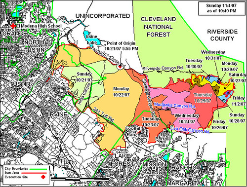
Earlier OCFA maps:
- Santiago Incident Wildfire OCFA Map 5, October 26, 2007
- Santiago Incident Wildfire OCFA Map 4, October, 24, 2007
- Santiago Incident Wildfire OCFA Map 3 October, 22 2007
- Santiago Incident Wildfire OCFA Map 2, October 22, 2oo7
- Santiago Incident Wildfire OCFA Map, October 21, 2007
- OC Register, Irvine Wildfire Map, October 21, 2007
Other Map sources
- USDA Forest Service Wildfire Maps – Remote Sensing Applications Center (updated every 4 hours, archive)
- OCFA fire maps
Blogs, photos and forums

Photo by atharkhan
![]()
- Flickr: Photos tagged Santiago Canyon Fire, Irvine, Foothill Ranch, Irvine + Fire
- Joel Sax’s blog and Twitter feed. Joel has been one of the best sources of information. (Portola Hills)
- Kelson Vibber is posting frequently: Oct 21, 22, 22, 23, 23 (Irvine)
- Rob on Twitter, also posted video from Sunday Night
- Leaving by Dawn (northwest Irvine)
- Jason Stone has posted some great photos, he’s also on Twitter and Flickr
- Laer has been posting daily: Oct 22, 23, 24 (Coto de Caza)
- Michelle Simmons is posting her experiences and photos: Oct 22, 22, 23
- Weather Today – blog by two climate scientists with notes and photos.
- Jason Rosenberg (also posting links)
- Danny Evans at Dad Gone Mad
- Deborah posted some thoughts
- OCFA photos and video (1.8mb WMV)
- Metroblogging OC has several posts, the comments are worth reading.
- Paul Epps
- Irvine Housing Forum discussion
- James Fabin: My Lexus at SoCal Fire (video)
- Craig Hockenberry on Twitter
youtube
Lots more video on YouTube: Irvine fire, Santiago Fire, Portola Fire
News Sites
Aside from the OC Register, early coverage of this fire has been lousy to non-existent. I’m only posting links to stories which add something new, most of what I’ve read has been useless dramatizing of the OCFA releases.
- Firefighters make stand against fire in Foothill Ranch – Los Angeles Times
- Authorities: Orange County Fire Was Arson – News Story – KNBC | Los Angeles
- OC Register: Fire reported in O.C.(original article)
- cbs2.com – Brush Fire Crosses Toll Road In Orange County (basic news rehash)
- 4,000 acres burning in O.C. – News – MSNBC.com (different network, same rehash)

THANK you for posting this. I’ve been looking everywhere for more information on the fire(s?) in Irvine.
Thanks for the comprehensive info! My family also lives in the area.
Thanks. I was looking for the links for a updated google map of the fire.
-H
Thank you very much for this site– I’m bookmarking it! I have family in Irvine and it was hard finding information about this fire. Now I can rest a little easier.
Thank you so much for creating this site! I live off of the 5 and Culver, and so I am trying to keep tabs on everything to stay safe!
My son Ben is a USFS Wildland Firefighter (Hotshot Crew), these guys are like the special forces for firefighters.
He texted me that his crew was being redirected to your fire as of 10am this morning. They were on the Santa Barbara wildfire (now contained).
He’s probably excited as he is from Newport.
I find it interesting that he is being sent there as his 12 man crew usually goes to the most rugged terrain type fires.
I have also been fustrated by lack of info on these fires. I think the fire command structure is streached so thin that they have abandoned frequent posting and updating on the INCIweb. Most of the SoCal fires are not even listed. Whenever my son is deployed I can usually follow the firefight progress on that site.
He told me in the beginning of the fire season that his bosses were afraid California was going to burn this year. Ironically he and his crew were going to be let go this week as most felt the season was over. I’m sure he is happy to be working but not under these circumstances. As a parent with a son in harms way, I would have a few things to say to an arsonist (don’t get me started).
thanks for this site…the news on the tv is good, but since they are only showing the MOST dangerous place at the time, i am not getting the local info i need. i am in lake forest…closest cross streets are lake forest and dimension. i can see some spot fires on the hills from right outside of my apartment now. don’t think they are new fires…just “small” ones that keep popping up in the same area of the hills behind foothill ranch/portola area. still scary, though.
Daniel, I’m sure your son knows how much he and his fellow firefighters are appreciated, even when they’re not standing between a brush fire and someone’s home. But thank him again anyway for all of us.
Thanks and I’m always thanking him. Amazed actually. Ben is in his early 20’s and a house framer by trade. This is his first season as a Hotshot. He gave up a good income to do this work.
These guys are animals. Not uncommon for them to walk 10 miles into a fire and fight it till they call em off and then walk out. At the Klamath fire up north his and other hand crews cut 28 miles of continouus fire line and saved a town. Last month at the Butler fire it was his crew in the middle of it calling air strikes and saving Fawnskin. These Hotshot crews go where you can’t get engine or dozers. Your right, they don’t generally do home protection, thats what engine crews are for. They flank and contain wildfires.
Which is what is happening at this fire.
He texted me about 10pm last night and said they had to call them off due to the “narly winds”. I’ll hear from him tonight when he’s pulled off again and I’ll report back here if he tells me anything new. I know he was really charged up for this one being so close to home. Be safe out there.
And double thanks for this page Joe. I’ve found the best info via this site and links. Inciweb is telling me nothing but I haven’t checked it yet today, came right here first.
24 HOUR SANTIAGO FIRE INFORMATION LINE (a real person): You can call this line to find out exactly where the fire is. I live in Rancho Santa Margarita where it meets Trabuco Canyone. I called to find out how long it will take the fire to reach my area.
As of 6 PM last night, the projected time that they estimate the fire will reach RSM was in 24 hours. This is only and estimate and it is subject to change, depending on wind direction, etc.
I spoke to a woman at that number and she was very helpful. They are on the phone lines 24/7 while this crisis is happening. Take care all.
24 HOUR SANTIAGO FIRE INFORMATION LINE (a real person): 714-573-6200
You can call this line to find out exactly where the fire is. I live in Rancho Santa Margarita where it meets Trabuco Canyone. I called to find out how long it will take the fire to reach my area.
As of 6 PM last night, the projected time that they estimate the fire will reach RSM was in 24 hours. This is only and estimate and it is subject to change, depending on wind direction, etc.
I spoke to a woman at that number and she was very helpful. They are on the phone lines 24/7 while this crisis is happening. Take care all.
Some anxiety waiting for Ben (USFS Hotshot crew member)to txt me. I assumed he was on fire all night. I was right.
Txt from Ben this am at 9.
“doin good, was up late, saved some homes, the fire was bearin down we had to work fast then we back burned off the homes, the fire is ragin 100ft flame lengths.”
Anymore info I’ll post here. From the other reports looks like they are dealing with it.
Tough fire in the back country, really rough terrain with loads of fuels.
After containment they go into what they call a demo stage. I think this means they go and put out hotspots and make sure the fire dosen’t start back up.
The crews must be tired but I know they will bust thier humps to get it under control.
Well I can see fire is finally on INCIWeb. USFS is going to take it over, I assume because it’s going into the Cleveland Nat Forrest. I also notice no containment prediction (unusual). They site lack of reasources on the fire. They may allow it to rage around the backcountry for awhile and try to control and defend. Be safe everyone and pray for those firefighters.
Inciweb site http://www.inciweb.org is now being updated every few hours or so.
Latest projection for fire movement (2 hrs ago) – “12 Hours: The fire is moving to the north, east and somewhat to the south. Fire has reached to the east within 1 mile of Modjeska Peak.”
and
“24 Hours: Continue spread to the north and east.”
Fire crews are continuing to back burn around homes and structures.
Bens fine im sure but hasen’t texed since thursday am. I hope he is getting some rest.
The INCIweb is a good source for info if they continue to update it normally.
I hope my anxious postings on this page are not annoying and I appreciate the good links.
My last post here. Thanks again for this site Joe.
Inciweb is up and running. It states your fire is 65% contained and 11/2 predicted for full containment.
Check out links on that site and use refresh button to check for latest updates that may have posted during your time there.
Correction to an earlier post of mine. Demo stage in the firefighter vernacular means demoblization. Sometimes they will use the term “demo” or “demob” interchangabley.
Bens crew and his sister crew from the same camp have been demo’d out. They are ending thier fire season and will soon be home.
Thanks again.